

Vigorous Winter - January 2014
Much of the world had extreme winter conditions in late December and January. The Central and Eastern US had many record breaking low temperatures and stormy winter weather while the West had record warm and drought conditions. The Polar Jet stream was very strong with a near zonal flow from North Africa thru Asia and across the Pacific to north of Hawaii where it took a sharp turn to the north into Alaska and then south around a quaisi - stationary polar vortex over the Hudson Bay region. This Low pulled down very cold Arctic air into Eastern North America and triggered many strong coastal storms that moved into the North Atlantic where they maintained a strong Icelandic Low. This produced a strong southerly flow that warmed Western Europe and the UK, while generating an extreme snowstorm over Norway with 1-2 meter deep snowfall. Figure 1 shows the 300 mb analysis by the US Navy NOGAPS global model on January 22, 2014 from the Navy Research Laboratory's operational global modleing web page.

Figure 1. NOGAPS 300 mb Northern Hemisphere analysis on Jan 21, 2014 at 1200 UTC.
Note the zonal jet stream flow across the Pacific to 180 W then the sharp northern flow to Alaska and polar vortex flow over eastern North America. A vigorous storm exits New England, where 15-18 inches of snow fell and temperatures dropped to 0 F.
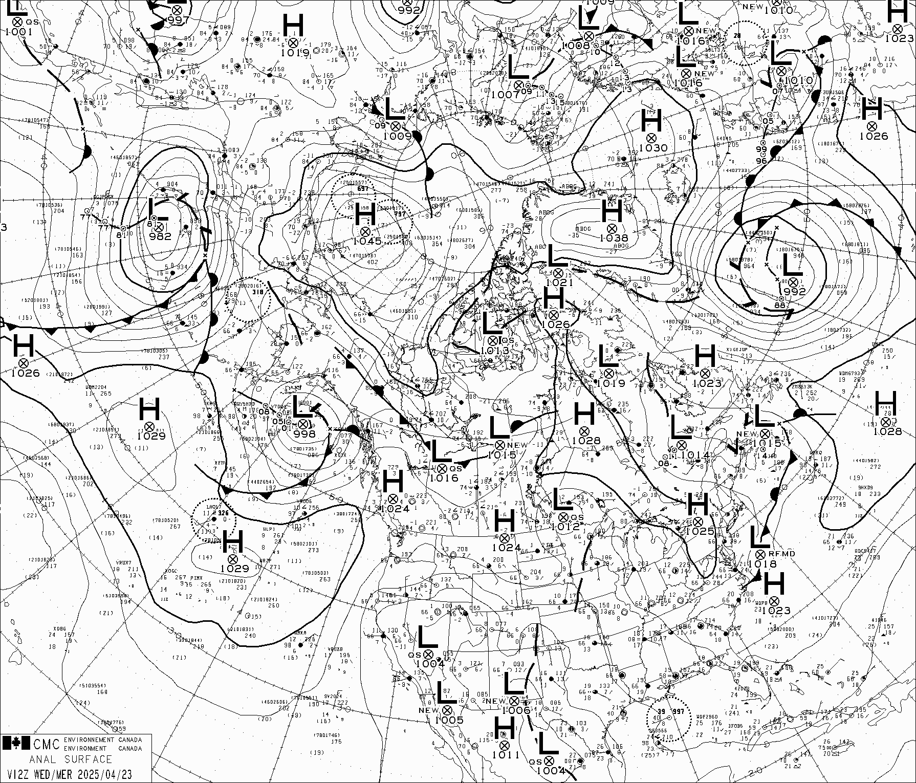
This deep cold low over Eastern Canada continued to maintain the extreme cold "Polar Vortex" pattern shown on the Environment Canada analysis of 26 January 2014 shown in figures 2 and 3 for the northern hemisphere surface and 250 mb analyses at 1200 UTC. Note the deep low ( 977 mb ) over Laborador and the upper level low centered on Hudson Bay with the western North American Ridge on the west coast extending into Alaska. This ridge of warm air flowing northward into Alaska and the Yukon Territory provided strong moisture flux from the Pacific which recurved south into the Polar Vortex and produced heavy snows across central N America to New England. In early January this same flux added to the snow pack in the Colorado Rockies.

Figure 2. Northern Hemisphere Polar regions surface analysis on 26 Jan 2014 at 1200 UTC.

Figure 3. Same as Fig. 2 for the 250 mb level model analysis showing the "polar Vortex" over Hudson Bay.
The sea surface temperatures (SST) have remained 2-3 C above normal in the east north Pacific as shown in figure 2. This warm water provides significant energy for the series of very intense Aleutian Lows which helped maintain the ridge along western North America between them and the polar vortex over Hudson Bay region of eastern Canada. This quasi-stationary pattern reinforced the extremely cold winter in the East.

Figure 2. Sea Surface Temperature (SST) anomaly for Jan 12 to 18, 2014 from NOAA's Earth Systems Research Laboratory's PSD Map Room . Note the very warm NE Pacific anomaly south of Alaska, and moderate warm anomaly on the East Coast of North America. There is a weak la Ninja. This configuration of SST is likely responsible in part for the quaisi-stationary jet stream pattern that has kept Eastern North America very cold and western Europe relatively warm. The Antarctic has also had a very strong summer jet stream pattern this Janurary which resulted in unusually cool temperatures in New Zealand and Australia, and strong storms off South America.

